

Navionics Software: A Guide for Boaters
If you are a boater, you probably know how important it is to have accurate and up-to-date charts of the waters you navigate. Whether you are cruising, fishing, sailing, or kayaking, having the right information can make your trip safer, easier, and more enjoyable. But how do you get the best charts for your needs? One option is to use Navionics software.
Navionics is a company that specializes in creating electronic charts for marine navigation. They offer a range of products and services, such as:
– Navionics+ : A subscription service that gives you access to more than 2,000 charts covering the whole world, including coastal and inland waters. You can download the charts to your mobile device or plotter and update them anytime with the latest data.
– Navionics Platinum+ : A premium service that adds high-resolution satellite imagery, 3D views, panoramic photos, and sonar charts to your Navionics+ subscription. You can also create your own sonar charts with your compatible fishfinder or sounder.
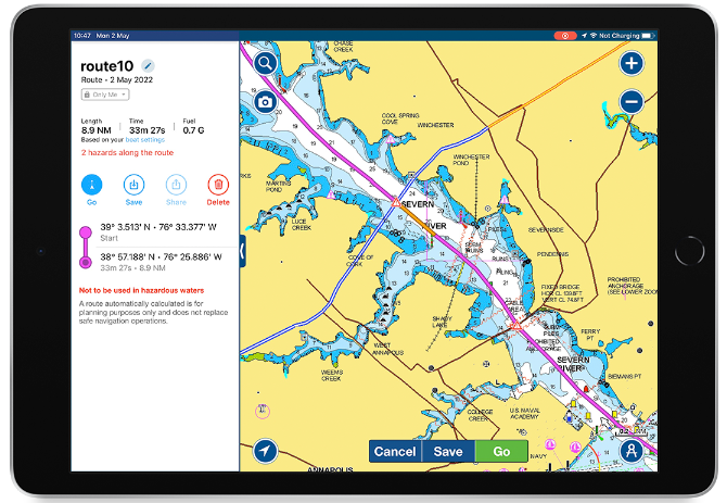
– Navionics Boating App : A free app that lets you use your smartphone or tablet as a chartplotter. You can view the Navionics charts, plan routes, track your position, record your trips, and share them with others. You can also access weather forecasts, tide and current information, points of interest, and community edits.
– Navionics Web App : A web-based app that lets you explore the Navionics charts on your computer. You can zoom in and out, measure distances, search for locations, and see the details of each chart. You can also overlay weather data, wind forecasts, and AIS data.
Navionics software is compatible with many devices and platforms, such as:
– iOS and Android devices
– Windows and Mac computers
– Garmin, Raymarine, Simrad, Lowrance, B&G, Humminbird, Furuno, and other plotters
– NMEA 2000 networks
– Wi-Fi and Bluetooth connections
Navionics software is easy to use and offers many features and benefits, such as:
– High-quality and accurate charts that are updated daily with official sources and user contributions
– Seamless coverage of the entire world with no gaps or overlaps
– Offline access to the charts without internet connection
– Customizable display options to suit your preferences and needs
– Advanced route planning and navigation tools with automatic guidance and alerts
– Integration with other instruments and sensors on board
– Ability to create and share your own maps and data with other users
– Access to a large community of boaters who share tips, feedback, and experiences
Navionics software is a great choice for boaters who want to have the best charts for their adventures. Whether you are a beginner or an expert, you can find the product that suits your budget and needs. To learn more about Navionics software, visit their website or contact their customer support.