
Picture yourself on a serene sailboat, cruising across the open waters, the wind in your hair, and the sun warming your face. As you navigate through unfamiliar territories, you might wonder, “How do you interpret and use nautical charts and GPS for navigation?” Whether you’re an experienced sailor or a novice adventurer, understanding the key principles of nautical charts and the assistance offered by GPS devices is crucial for a successful and safe voyage. In this article, we will explore the intricacies of nautical charts and GPS systems, unlocking the secrets that will guide you through even the most challenging waters. So, grab a lifejacket and let’s set sail!
Understanding Nautical Charts
What are nautical charts?
Nautical charts are specialized maps used by mariners to navigate safely and effectively on the water. They provide detailed information about the physical features of bodies of water including coastlines, water depths, navigational aids, and potential hazards. Nautical charts are essential tools for planning routes, avoiding dangers, and ensuring the safety of vessels and passengers.
Types of nautical charts
There are various types of nautical charts available depending on the specific needs of mariners. NOAA (National Oceanic and Atmospheric Administration) produces official nautical charts for the coastal waters of the United States. These charts provide accurate and up-to-date information for safe navigation. In addition to official charts, there are also commercial charts, which may offer additional features and coverage for popular boating destinations. Electronic navigational charts (ENCs) are digital versions of nautical charts, which can be used with GPS systems for real-time navigation.
Where to obtain nautical charts
Nautical charts can be obtained from various sources. Official nautical charts can be purchased from authorized chart agents, which include both physical and online stores. NOAA provides an online chart viewer where users can access and download digital versions of their charts for free. Commercial charts can be purchased from boating supply stores or reputable online retailers. Additionally, some boating apps and GPS systems offer access to digital charts for use on mobile devices.
Components of a nautical chart
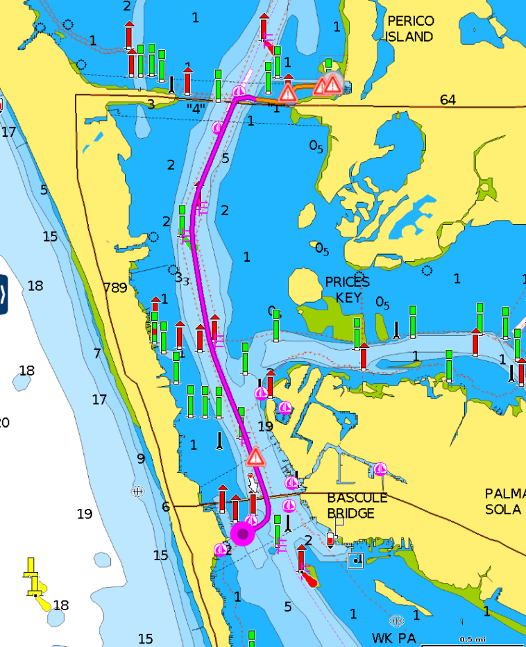
A nautical chart consists of several key components that provide essential information for navigation. The title block, located in the top corner, displays the chart number, scale, and edition information. The compass rose, usually found near the center of the chart, provides a reference for magnetic and true north. Depth and underwater features are depicted using depth contours, which are lines that connect points of equal depth. Navigational aids such as buoys and lighthouses are marked with distinct symbols. The chart also includes topographic features such as islands, shorelines, and landmarks. Tidal information, including tidal currents and heights, is shown on the chart. Finally, navigational hazards such as rocks, wrecks, and shoals are marked with appropriate symbols.
Navigational Information on Nautical Charts
Depth and underwater features
One of the most critical pieces of information provided on nautical charts is the water depth. Depth contours, represented by lines of varying thickness or color, indicate the shape and depth of the seabed. These contours help mariners identify channels, shoals, and other underwater features that may pose a risk to navigation. Soundings, which are marked as numbers on the chart, provide the specific depth at specific locations. By understanding the depth and underwater features, mariners can determine safe passages and avoid running aground.
Aids to navigation
Navigational aids are markers and beacons that help mariners identify safe navigation routes. These aids include buoys, which can mark channels, hazards, or navigational boundaries, and lighthouses, which provide a visible reference point for mariners. Each navigational aid is labeled with a unique symbol and may be accompanied by additional information such as light characteristics, fog signals, and radio frequencies. By referencing these aids on nautical charts, mariners can navigate safely and precisely.
Topographic features
Nautical charts also include topographic features such as islands, shorelines, and landmarks. These features provide visual references that aid mariners in determining their position and identifying points of interest. Islands and shorelines are depicted with accurate shapes and may include additional information such as elevations, vegetation, and man-made structures. Landmarks, such as prominent buildings or structures, serve as visual aids for navigation and can be used in combination with other navigational information on the chart.
Tidal information
Tidal information is crucial for safe navigation, especially in areas with significant tidal fluctuations. Nautical charts include tidal data, such as tidal currents and heights, which help mariners plan their routes and time their passages accordingly. Tidal currents show the speed and direction of the water flow during specific tidal phases, while tidal heights indicate the vertical distance between the water level and a reference point. By considering tidal information, mariners can navigate more efficiently and avoid challenging conditions caused by tidal currents.
Navigational hazards
Navigational hazards, such as rocks, wrecks, and shoals, are marked on nautical charts to warn mariners of potential dangers. These hazards can pose a threat to vessels if not avoided or approached with caution. Nautical charts use specific symbols and labels to indicate the type and location of these hazards. By being aware of the navigational hazards depicted on the chart, mariners can plan their routes to steer clear of dangerous areas and ensure the safety of their vessel and passengers.
Interpreting Nautical Chart Symbols
Depiction of land and water
Nautical charts use specific symbols and colors to represent land and water features. Water is typically depicted in a light blue color, while land areas are shown in various shades of brown and green. This distinction helps mariners differentiate between open water and land masses when interpreting the chart. Additionally, the chart may include labels for prominent land features such as capes, points, and bays, providing reference points for navigation.
Shoreline and coastal features
The shoreline and coastal features on nautical charts are depicted with accuracy and detail. The shape and contours of the coastline are shown, along with various natural and man-made features. Inlets, coves, beaches, and cliffs are represented with specific symbols and labels to aid mariners in identifying their location and planning their navigation along the coast. These coastal features serve as visual references and assist mariners in determining their position relative to the land.
Navigational aids and markers
Navigational aids, such as buoys, beacons, and lighthouses, are illustrated on nautical charts using distinct symbols. Each symbol represents a specific type of aid and may include additional information such as light characteristics, fog signals, or radio frequencies. By understanding these symbols, mariners can quickly identify navigational aids while navigating and use them as reference points for plotting their course.
Depth contours and soundings
Depth contours, represented by lines of varying thickness or color, provide information about the shape and depth of the seabed. These contours help mariners visualize the underwater terrain and identify safe navigation routes. Soundings, marked as numbers on the chart, provide specific depth measurements at particular locations. By interpreting the depth contours and soundings, mariners can determine the depth of the water and locate channels or deep areas for safe passage.
Hazard symbols
Hazard symbols on nautical charts alert mariners to potential dangers lurking beneath the water’s surface. These symbols represent various hazards such as rocks, wrecks, shoals, or obstructions. Hazard symbols may include additional information such as the nature of the hazard and its location. By recognizing these symbols, mariners can avoid hazardous areas and navigate around potential obstacles that could harm their vessel.
Using Nautical Charts for Route Planning
Identifying the desired route
When using nautical charts for route planning, the first step is to identify the desired route. This involves considering factors such as the destination, navigational aids along the way, and any specific areas to avoid. By studying the chart and identifying key points, mariners can plan a safe and efficient route from start to finish.
Determining distances and bearings
Nautical charts provide distances and bearings between various points on the chart. By using the latitude and longitude scales, mariners can measure the distance between two adjacent points or calculate the bearing from one point to another. These measurements help mariners plan their route and estimate travel times. By considering distances and bearings, mariners can navigate accurately and reach their destination on time.
Considering navigational hazards
Navigational hazards, such as rocks, wrecks, and shoals, must be taken into account when planning a route. Nautical charts indicate the location and extent of these hazards, allowing mariners to plot a course that avoids them. By identifying potential hazards along the desired route, mariners can select a safe and clear path, minimizing the risk of accidents or damage to their vessel.
Accounting for tidal and current effects
Tidal and current effects can significantly impact a vessel’s speed, course, and arrival time. When planning a route, mariners must consider the tidal and current conditions at different times of the day. Nautical charts provide information on tidal currents, including speed and direction, and the tidal heights for specific locations. By factoring in these tidal and current effects, mariners can adjust their route plans and take advantage of favorable conditions while avoiding unfavorable ones.
Selecting alternate routes
When planning a route, it is essential to consider the availability of alternate routes in case unexpected circumstances arise. Nautical charts can help mariners identify alternative channels or passages that can be used if the primary route becomes inaccessible or unsafe. By familiarizing themselves with these alternate routes in advance, mariners can quickly adapt to changing conditions and navigate confidently.
Working with Nautical Chart Scales
Understanding chart scale ratios
Chart scale ratios represent the relationship between the distance on the chart and the corresponding distance on the Earth’s surface. For example, a chart with a scale ratio of 1:50,000 means that one unit of measure on the chart represents 50,000 units of measure on the Earth’s surface. Understanding chart scale ratios is crucial for accurate navigation and distance calculations.
Choosing an appropriate chart scale
When using nautical charts, it is essential to choose an appropriate chart scale based on the specific navigation requirements. A larger scale chart, such as 1:10,000, provides more detailed information for close-up navigation in confined waters. On the other hand, a smaller scale chart, such as 1:100,000, covers a larger area but with less detail. The choice of chart scale depends on factors such as the size and type of vessel, the complexity of the waters being navigated, and the level of detail required.
Interpreting distances on nautical charts
Nautical charts provide various methods for interpreting distances. The latitude and longitude scales can be used to measure the distance between two points by using the appropriate latitude scale for the latitude of the chosen route. Additionally, some charts include distance scales in nautical miles or nautical leagues. These scales allow mariners to determine the distance between points by aligning the distance scale with the desired route. By understanding these methods of distance interpretation, mariners can navigate accurately and estimate travel times effectively.
Using GPS for Navigation
Introduction to GPS technology
GPS (Global Positioning System) is a satellite-based navigation system that provides precise location and positioning information. GPS technology relies on a network of satellites orbiting the Earth, which transmit signals to GPS receivers. These receivers, commonly found in smartphones or dedicated GPS devices, calculate the user’s position based on the signals received from multiple satellites. GPS technology has revolutionized navigation by providing accurate real-time positioning information anywhere on the planet.
Benefits and limitations of GPS
GPS offers numerous benefits for navigation. It provides accurate and reliable position information, making it easier for mariners to navigate and maintain their course. GPS can also provide real-time data on vessel speed, heading, and altitude. Furthermore, GPS allows for easy route planning, as it can calculate distances and bearings between waypoints. However, GPS does have limitations, including potential signal loss in areas with poor satellite visibility, the need for a clear view of the sky for accurate positioning, and potential inaccuracies caused by signal interference or multipath reflection.
Understanding GPS coordinates
GPS coordinates are a set of numerical values that specify a precise location on the Earth’s surface. They consist of latitude and longitude, which are measured in degrees, minutes, and seconds. Latitude represents the distance north or south of the equator, while longitude represents the distance east or west of the Prime Meridian. GPS coordinates help mariners pinpoint their exact position on the water and can be used to plot routes, mark waypoints, and navigate with precision.
Determining position using GPS
To determine their position using GPS, mariners need a GPS receiver that can acquire signals from at least four satellites. The receiver measures the time it takes for the signals to reach it from each satellite and calculates the distance to each satellite based on the speed of light. By intersecting these distance measurements, the GPS receiver determines the user’s precise position on the Earth’s surface. Once the position is determined, the GPS receiver continuously updates the user’s location as they move, providing real-time navigation information.
Using GPS in Conjunction with Nautical Charts
Overlays and integration with GPS
Many modern GPS devices and boating apps allow for the overlay and integration of GPS information with nautical charts. This integration allows mariners to view their GPS position directly on the chart, enhancing situational awareness and improving navigation. The GPS position marker can be displayed as a symbol on the chart, moving in real-time as the vessel progresses along its route. This integration of GPS and nautical charts provides a powerful tool for navigation and ensures accurate positioning and course tracking.
Calibrating GPS with nautical charts
To ensure accurate GPS positioning on nautical charts, it is essential to calibrate the GPS device or app with the specific chart being used. Calibration involves aligning the GPS position displayed on the device with the corresponding location on the chart. This can be done by manually entering the chart’s coordinates or by selecting a known point on the chart and confirming its GPS coordinates. By calibrating the GPS with the nautical chart, mariners can trust the accuracy of their GPS position relative to the chart’s features.
Using GPS to confirm charted features
GPS can be a valuable tool for confirming the accuracy of charted features. By comparing the GPS position with the charted position of known landmarks, navigational aids, or hazards, mariners can verify the reliability of the chart’s information. This confirmation helps build confidence in the chart’s accuracy and ensures that mariners can navigate safely based on the information provided.
Leveraging real-time data with GPS
One significant advantage of using GPS for navigation is the ability to access and leverage real-time data. GPS devices and apps can provide real-time information such as vessel speed, heading, and altitude. This data can help mariners make informed decisions while navigating, especially when faced with changing conditions or unexpected situations. By combining real-time GPS data with nautical charts, mariners can adapt their navigation plans and ensure a safe and efficient passage.
Navigating with GPS
Setting waypoints and routes
GPS devices and apps allow mariners to set waypoints and routes, which are essential for efficient and accurate navigation. Waypoints are specific locations marked on the GPS system, such as buoys, landmarks, or turns in a channel. Routes are a series of connected waypoints that define a planned course. By setting waypoints and creating routes, mariners can follow predetermined paths, navigate accurately, and avoid potential hazards.
Following a GPS route
Following a GPS route involves navigating along a predetermined path marked by waypoints. GPS devices and apps provide visual and audible cues to guide mariners along the route. These cues can include distance to the next waypoint, the desired heading, and graphical representation of the route on the GPS display. By following the GPS route, mariners can navigate accurately and confidently, even in challenging or unfamiliar waters.
Utilizing GPS for position fixing
GPS technology allows mariners to fix their position with pinpoint accuracy. By comparing the GPS position with the charted features or known landmarks, mariners can precisely determine their location on the water. This position fixing ability is particularly useful when navigating in low visibility conditions, during the night, or in unfamiliar areas. By utilizing GPS for position fixing, mariners can maintain situational awareness and safely navigate to their intended destination.
Using GPS for route deviation alerts
GPS devices and apps can provide route deviation alerts to warn mariners if they stray from the planned route. These alerts can include visual and audible notifications whenever the vessel deviates beyond a specified distance or angle from the intended route. By utilizing GPS for route deviation alerts, mariners can quickly correct their course and avoid accidental navigational errors, ensuring they stay on track towards their destination.
Skills and Techniques for Effective Navigation
Dead reckoning
Dead reckoning is a navigational technique that involves estimating the vessel’s position based on the previously known position, course, speed, and time. By continuously updating these factors and applying them to the vessel’s movement, mariners can approximate their current position using dead reckoning. This technique is particularly useful when GPS signals are unavailable or as a backup method for navigation.
Compass navigation
Compass navigation is a fundamental skill for mariners. By using a magnetic compass, mariners can determine their vessel’s heading and set a course relative to magnetic North. A compass allows mariners to navigate even in the absence of GPS technology or when electronic navigation systems are unavailable or unreliable.
Using range lines and transits
Range lines and transits are visual aids that help mariners navigate in a channel or along a specific path. A range line consists of two visible marks or objects that, when aligned, indicate a centerline or safe passage through a channel. Transits involve identifying two or more fixed objects on the shore that, when aligned, create a bearing that signifies the desired course. By using range lines and transits, mariners can maintain proper alignment and navigate accurately.
Using visual and electronic aids together
Mariners can enhance their navigation skills by combining visual aids, such as landmarks and buoys, with electronic aids like GPS and nautical charts. Visual aids provide real-time references that can be used in conjunction with the information displayed on electronic devices. By cross-referencing visual and electronic aids, mariners can confirm their position, validate their course, and navigate safely.
Staying alert and monitoring progress
Navigating safely and effectively requires constant vigilance and monitoring of progress. Mariners must stay alert to changes in the environment, including shifting weather conditions, traffic, and navigational hazards. By regularly checking their position on the chart, confirming their GPS position, and monitoring their vessel’s progress, mariners can make informed decisions and react promptly to any changes or challenges they encounter.
Best Practices and Safety Considerations
Updating nautical charts and GPS systems
To ensure accurate navigation, it is crucial to keep nautical charts and GPS systems up to date. Nautical charts can change over time due to shifting coastlines, new navigational aids, or changes in hazards. Mariners should regularly check for updates and acquire the latest edition or update their digital charts. Similarly, GPS systems should be regularly updated with the latest satellite information and firmware upgrades provided by the manufacturer or service provider. By maintaining up-to-date charts and GPS systems, mariners can rely on accurate information for safe navigation.
Maintaining a backup plan
Even with advanced navigation technology, mariners should always have a backup plan. This includes having physical nautical charts onboard as a backup to electronic charts and carrying traditional navigational tools such as compasses, dividers, and parallel rulers. In the event of GPS signal loss or equipment failure, a backup plan ensures that mariners can still navigate and safely reach their destination.
Monitoring battery life and connectivity
For those using GPS devices or apps, monitoring battery life and connectivity is vital for uninterrupted navigation. Mariners should ensure that their GPS devices are fully charged before each voyage and carry spare batteries or charging options if necessary. Additionally, maintaining a stable and reliable connection to GPS satellites is essential for accurate positioning. Mariners should be aware of potential signal obstructions, such as tall buildings or dense tree foliage, and position themselves accordingly to maintain a clear view of the sky.
Accounting for environmental factors
When navigating, mariners must account for environmental factors that can affect their vessel’s performance and safety. This includes considering wind, waves, tides, currents, and weather conditions. Understanding how these factors impact the vessel’s speed, stability, and maneuverability allows mariners to adjust their navigation plans accordingly and ensure a safe passage.
Following local regulations
Navigating safely requires adhering to local regulations and guidelines. These may include speed limits, restricted areas, traffic separation schemes, or specific rules for harbors and ports. Mariners should familiarize themselves with the applicable regulations and ensure compliance to avoid fines, penalties, or endangering themselves and others. By following local regulations, mariners can navigate responsibly and contribute to a safe and orderly boating environment.
By understanding nautical charts and utilizing GPS technology effectively, mariners can navigate with confidence and enhance their safety on the water. Taking the time to interpret nautical chart symbols, plan routes, and develop navigation skills ensures a successful and enjoyable boating experience. Remember to keep the best practices and safety considerations in mind, and always prioritize the safety of yourself, your passengers, and your vessel. Happy sailing!